About District:

Tenkasi is located in the Southwestern part of Tamil Nadu, surrounded by Virudhunagar district in the north, Western Ghats and Kerala in the west, the South East is covered by Tirunelveli district and North East by Thoothukudi district. Tenkasi district was bifurcated Tirunelveli district on 12.11.2019 vide G.O.(MS) No.427, Revenue and Disaster Management [RAI (1)] Department, 12.11.2019. District headquarters is Tenkasi, which is the largest Municipality in Tenkasi District. Tenkasi is named after Kasi Viswanathar Temple, built by the Pandian ruler Parakkirrama Pandian during the 13th Century.

The Geographical area of the district is 2882.44 sq.kms which lies in the southwest part of Tamil Nadu. It lies in between 8º.57′ and 8º.95′ of the Northern latitude and 77º.18′ and 77º.31′ of Eastern longitude.. The Population of the district is 14,40,795 as per 2011 census. The density of population per sq.km was 500 persons in the 2011 census.
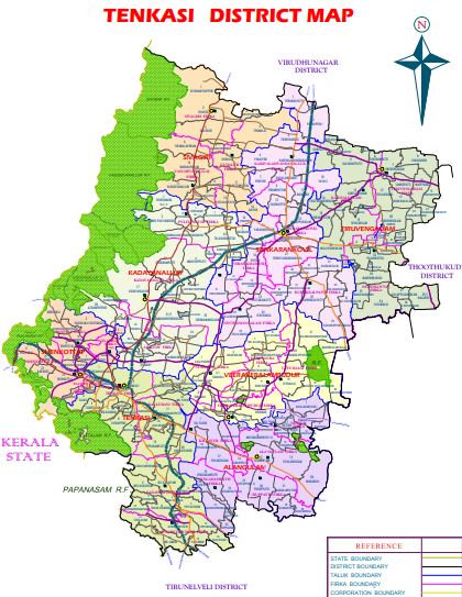
The district is blessed with Western Ghats from which all the rivers viz, Chitharu, Hanuman Nathi, Ramanathi and Karuppanathi flows from west to east. Gundaru, Adavinainar, Karuppanathi, Gadana, Ramanathi are the main source of irrigation dams and also for drinking purpose. The other sources of irrigation are wells, tanks and canals.

Agriculture is playing a very crucial role in the district economy. Paddy is cultivated as major crop in the district and Coconut, Cashew nut, Mango, Maize and Cotton are other principal crops. Lemon Cultivation is famous in Puliyangudi, and it is popularly known as “Lemon City”.

Company Statistics Analysis

Great Achievement For Insurance

8563 +

Saticfied Custimer

2630 +

Experience Members

100 %

Satisfaction Rate

25 +

Years Experience

963 +

Awards Winning

Popular Clients

We’ve 1520+ Global Premium Clients